summary
Before
The earliest reference for the name Koitiata is in maps from pre-1909, which show Koitiata Stream. A 1914 map shows Koitiata Survey District, Koitiata Stream, and Lake Koitiata. They appeared to be the only three uses of the name before the village being established.
A report in The Rangitikei Advocate in July 1913, tells of Turakina Heads being popular for camping and fishing, and also reports that some Turakina residents were seeking to have land for a ‘seaside resort’. In 1913, they formed a committee to pursue the project, and a 1914 report stated that they had been successful and that the land requirement for the ‘resort’ would be actioned by the government.
A survey map dated 1915 shows the planned ‘seaside resort’, and a later map (circa 1917/18) shows the 165-acre reserve named as Koitiata Domain. That map has an outline of a proposed Koitiata Town, and that is the first recorded usage of the name Koitiata being applied to the village.
Begins
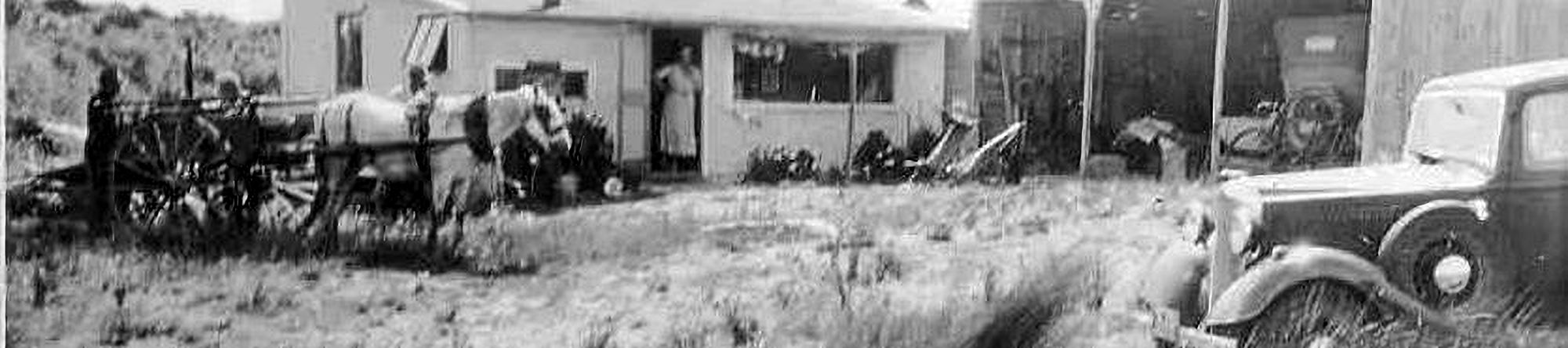
At the beginning of 1917 there was a Koitiata Domain but no surveyed village. Authorisation was given by the Government later in 1917 for the erection of seaside cottages. Reports stated that camping was quite popular, and there were a few ‘substantial’ camping structures existing before the setting up of Koitiata township.
The Koitiata Domain Board was established, and they resolved to establish the most suitable position for seaside cottages, and also decided to grant one-year leases to those who had already erected cottages, to apply from 1st January 1918.
It is reasonable to claim that Koitiata had already been established, by those who created that early camping village that existed at the beginning of 1917. In January 1918, the site for the planned township was selected, with a map dated July 1918, laying out the beginning of the surveyed Township of Koitiata.
shaky start
In 1919, 30 sections in Rapaki Street were auctioned for lease at £1 per year, and a year later a report stated that 11 sections had been sold. A condition of lease was, ‘lessee to take precautions to prevent sand drift’. But that prevention was going to be a difficult and drawn out process.
From reports;
Nov 1924: “… sand has drifted over sections 23 to 41 which are now practically useless … of 41 sections surveyed there are only a dozen of any use …”
Dec 1924: “The site where the township is laid out has as far back as the European Settlers in the district could remember been a grass valley and free from any serious encroachment of sand drift. The place has been a favourite camping ground for years past. During the last two years the position has changed, and the sand has encroached on the seaward side of the township and is threatening to further encroach from this direction and from the north side.”
Buildings from Rapaki street were relocated to Omanu street area, others abandoned or demolished. An aerial photo from 1942 shows no buildings visible where the village started. It shows 14 located outside the designated township boundaries around the Wainui and Omanu street junction.
village grows
A 1950 map shows 15 ‘buildings’ in the Omanu street area, with Rapaki street still empty. Then it appears that finally the ‘dust had settled’ in Rapaki street. A 1952 map shows all the Rapaki and the new Omanu street sections having owners names marked on them. The ‘shaky start’ was history!
Most of the buildings in the village were established during the 1950s and 1960s period, which appears to have been a boom time for Koitiata. That demand was the catalyst for the rest of Wainui street being extended, from the hall to the village entrance, those sections being made available in 1964. There was a waiting list when they were released, and all had been taken up by 1974.
A continuing demand for sections started the process to further extend the residential area of the village. After several false starts, plans were put in place to extend Rapaki street to the south. That extension added 18 sections, and the current camp ground, to the village in 1985, bringing the number of sections in Koitiata up to 117.
services
When the village started, it was an unserviced camp ground. The streets were only lines on a map, just tracks in the sand, through the marram grass, low scrub, lupins — and more sand. There was no electricity, no telephones, no street lights, no services of any kind. And that’s the way it was for almost the first fifty years.
Until 1968, the streets were gravel over sand, and sometimes under the sand. From records, it appears that it was 1969/70 before all streets were sealed in the village.
The electricity system came as far as the Tunnel Hill farm, 3 km away from Koitiata, the village being connected in 1965. At that time, a street lighting system was approved and finally installed in 1979. A phone box, which didn’t eventuate, was suggested in 1968, and there were some phone connections in 1972. The village became fully connected to the world, with a Wi-Fi internet and phone system installed in 2011.
other things
We are still at the beach more than a century after Koitiata began. During the period since 1917, floods have occurred, a fire brigade has been established, a hall and fire shed have been constructed, many social and community events have taken place, and of course, there was The Piano. And regular attempts to change the course of the river. Also, there were remains of shipwrecks on the beach.
The book, ‘100 Years At The Beach’, and the primary history content of this webpage records an expansive range of events and actions throughout the history of Koitiata. And it records the tenacity of those pioneers who persevered through the 1920s and beyond.